| ▲ Up ▲ | |||||
 on Thursday, July 11, flying to Anchorage Ted Stevens Airport (ANC) via Minneapolis - St. Paul International Airport (MSP). Due to equipment problems at MSP, we did not arrive in ANC until 1:30 am local time (5:30 am DC time) and did not get to our hotel room until after 2:30 am. Even that late it was still twilight in Anchorage with the \"setting sun\" horizon being to the north! The next morning we walked into downtown Anchorage and had breakfast at a local cafe. Next we went to the Anchorage Museum at Rasmuson Center where we purchased tickets for both the museum and the Alaska Native Heritage Center. We started by taking a complementary shuttle from the museum to the center where we first listened to a presentation on the center. Then we went for a walk around Lake Tiulana, the focal point of the center's outside exhibits. Our first stop was the Athabascan Village. Here Lucinda is looking out the door of a village house.") Alaska Trip - Anchorage - Alaska Native Heritage Center - Athabascan Village We departed Dulles Airport (IAD) on Thursday, July 11, flying to Anchorage Ted Stevens Airport (ANC) via Minneapolis - St. Paul International Airport (MSP). Due to equipment problems at MSP, we did not arrive in ANC until 1:30 am local time (5:30 am DC time) and did not get to our hotel room until after 2:30 am. Even that late it was still twilight in Anchorage with the "setting sun" horizon being to the north! The next morning we walked into downtown Anchorage and had breakfast at a local cafe. Next we went to the Anchorage Museum at Rasmuson Center where we purchased tickets for both the museum and the Alaska Native Heritage Center. We started by taking a complementary shuttle from the museum to the center where we first listened to a presentation on the center. Then we went for a walk around Lake Tiulana, the focal point of the center's outside exhibits. Our first stop was the Athabascan Village. Here Lucinda is looking out the door of a village house.   Alaska Trip - Anchorage - Alaska Native Heritage Center - Athabascan Village |
 Alaska Trip - Anchorage - Alaska Native Heritage Center - Bowhead Whale Jaw Bones Just outside the Inupiaq St Lawrence Island Yupik Village exhibits are two jaw bones from a bowhead whale embedded in the ground forming an arch. Lucinda and Ed found an obliging fellow tourist who took this picture of them framed by the arch. Lake Tiulana and the Center's main building is in the background.  Alaska Trip - Anchorage - Alaska Native Heritage Center - Bowhead Whale Jaw Bones |
 Alaska Trip - Anchorage - Alaska Native Heritage Center - Inupiaq St Lawrence Island Yupik Village We continued our walk around Lake Tiulana, visiting both the Yup’ik/Cup’ik Village with its earth covered houses and an Iditarod Sled Dog Facility. Neither of these stops produced photographs that I included in this album. The next stop was at the Inupiaq/St. Lawrence Island Yupik Village. This was a large, earth covered structure. True to her teacher instincts Lucinda questioned the center staff about the inhabitant's living customs.  Alaska Trip - Anchorage - Alaska Native Heritage Center - Inupiaq St Lawrence Island Yupik Village |
 Alaska Trip - Anchorage - Alaska Native Heritage Center - Eyak, Tlingit, Haida and Tsimshian Village Site Southern Tlingit Tall Totem Pole Continuing around Lake Tiulana is the Eyak, Tlingit, Haida and Tsimshian Village Site. All of these Alaska Native cultures are found in southeast Alaska. With all of the tall rain forest trees a resources, the southern Tlingit carved tall totem poles for the front of their houses. The village site includes a totem pole carving shed. This picture shows Ed in front of the tall totem pole at the site.  Alaska Trip - Anchorage - Alaska Native Heritage Center - Eyak, Tlingit, Haida and Tsimshian Village Site Southern Tlingit Tall Totem Pole |
 Alaska Trip - Anchorage - Alaska Native Heritage Center - Eyak, Tlingit, Haida and Tsimshian Village Site Northern Tlingit Short Frontal Totem Pole This is a picture of Lucinda in the same village site by a northern Tlingit frontal totem pole. Living in the north were the trees did not grow so tall, their totem poles were much shorter and occasionally placed inside their houses.  Alaska Trip - Anchorage - Alaska Native Heritage Center - Eyak, Tlingit, Haida and Tsimshian Village Site Northern Tlingit Short Frontal Totem Pole |
. The latter is the world's busiest seaplane base, averaging nearly 200 operations per day, in the summer on pontoons, in the winter on skis. There is also a gravel strip for land based aircraft. Ted Stevens Anchorage International Airport (ANC) is visible in the background. The trolley was not really suitable for photography, so this picture was down loaded from Wikipedia. Our trolley drove from right to left along the road just below the water and above the parked land planes") Lake Hood Seaplane Base and Gravel Strip We ate a reindeer hot dog lunch at the Center and took the shuttle back to the Anchorage Museum. They had two notable exhibits - one called "Arctic Flight - A Century of Alaska Aviation", the other a joint exhibit with the Smithsonian "Living Our Cultures, Sharing Our Heritage: The First Peoples of Alaska" . Unfortunately no pictures were allowed in the museum. After visiting the museum we took a Trolley Tour covering the western side of Anchorage. The tour featured 1963 earthquake related sites, and the Lake Hood Seaplane base (LHD). The latter is the world's busiest seaplane base, averaging nearly 200 operations per day, in the summer on pontoons, in the winter on skis. There is also a gravel strip for land based aircraft. Ted Stevens Anchorage International Airport (ANC) is visible in the background. The trolley was not really suitable for photography, so this picture was down loaded from Wikipedia. Our trolley drove from right to left along the road just below the water and above the parked land planes  Lake Hood Seaplane Base and Gravel Strip |
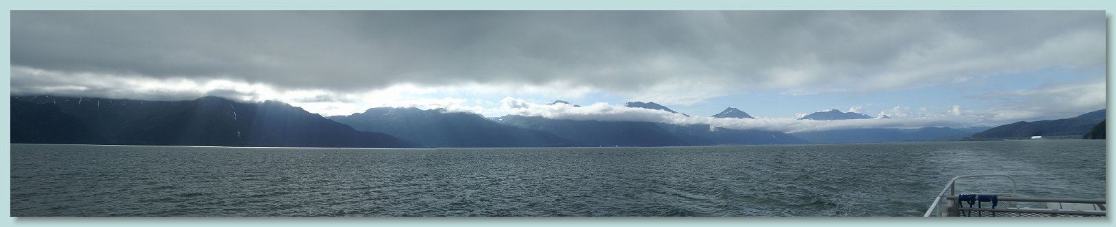
 which is 170 miles away. Unfortunately there was just enough haze to make for poor telephotos. This is the best of the pictures I took and I still had to Photoshop it extensively to bring out the details.") Alaska Trip - Seward Highway - Beluga Point On Saturday, after breakfast we were picked up at the hotel by Seward Bus Lines. They offered a morning sightseeing trip along the 125 mile Seward Highway. Our first stop was at Beluga Point. This is a good viewing point along Turnagain Arm for either seeing one of several pods of beluga whales which frequent the area or watching the bore tide come up the arm. Unfortunately neither occurred during our visit. However the weather was good and we could see Mount McKinley (also known as Denali) which is 170 miles away. Unfortunately there was just enough haze to make for poor telephotos. This is the best of the pictures I took and I still had to Photoshop it extensively to bring out the details.  Alaska Trip - Seward Highway - Beluga Point |
 at the end of Turnagain Arm. The AWCC provides care for hundreds of injured and/or displaced wild animals. Taken by fellow tourist, this is a picture of Ed and Lucinda in front of the Wood Bison herd enclosure. They were extinct in Alaska for over 100 years until his herd was brought from the Yukon Territory. The AWCC is part of a wood bison recovery/reintroduction program. In the picture behind Ed and Lucinda resting light colored calves can be seen.") Alaska Trip - Alaska Wildlife Conservation Center After a quick rest stop at Girdwood Alaska, the next sightseeing stop was the Alaska Wildlife Conservation Center (AWCC) at the end of Turnagain Arm. The AWCC provides care for hundreds of injured and/or displaced wild animals. Taken by fellow tourist, this is a picture of Ed and Lucinda in front of the Wood Bison herd enclosure. They were extinct in Alaska for over 100 years until his herd was brought from the Yukon Territory. The AWCC is part of a wood bison recovery/reintroduction program. In the picture behind Ed and Lucinda resting light colored calves can be seen.  Alaska Trip - Alaska Wildlife Conservation Center |
 Alaska Trip - Alaska Wildlife Conservation Center This is a second fellow tourist taken picture of Ed and Lucinda in front of the Roosevelt Elk herd enclosure which the AWCC maintains as part of Watchable Wildlife. Wild Roosevelt Elk in Alaska originated from the transplant of eight calves captured on the Olympic Peninsula of Washington State and moved to one of the Kodiak Islands in 1929. Since it was the middle of July their antlers which are shed and regrown every year are covered in velvet  Alaska Trip - Alaska Wildlife Conservation Center |
 Alaska Trip - Alaska Wildlife Conservation Center My only disappointment on the trip was not seeing any bears in the wild. This is the only one I saw on the entire trip - and it was at the AWCC. It is a black bear. Supposedly there were two brown, a grizzly and another black bear in the enclosure, however they were too well hidden for me to find.  Alaska Trip - Alaska Wildlife Conservation Center |
 Alaska Trip - Seward Highway - Canyon Creek Wayside at Mile 56.7 After spending over an hour at AWCC, we continued on our trip. The next stop was the Canyon Creek Wayside at Mile 56.7 of the Seward highway. The wayside overlooks the confluence of Sixmile and Canyon creeks. For these two pictures Lucinda and I alternated being photographer and subject. It looks north onto the Canyon Creek valley.  Alaska Trip - Seward Highway - Canyon Creek Wayside at Mile 56.7 |
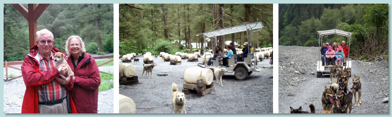
 Alaska Trip - Seward Marina Area - Seavey's Dog Sled Sculpture After we arrived in Seward and checked into our hotel we went for a walk around the Seward marina area. Among the attractions vying for attention was this wooden dog sled sculpture just outside the Seavey's tourist office. Since we would be going on their tour the next day, I took a picture of Lucinda sitting in the sled.  Alaska Trip - Seward Marina Area - Seavey's Dog Sled Sculpture |
 Alaska Tour - Major Marine Wile Life Tour of Resurection Bay That evening we had scheduled an Wildlife and Dinner Cruise of Resurrection Bay through Major Marine Tours. This was the picture that they took of us just before we boarded their boat "The Star of the Northwest". The dinner was reasonable and the surprise of the cruise was a US Park Ranger who narrated the cruise and was available to answer questions.  Alaska Tour - Major Marine Wile Life Tour of Resurection Bay |
Alaska Tour - Major Marine Wild Life Tour of Resurrection Bay - Bay Panorama As "The Star of the Northwest" left Seward harbor marina I took this panoramic view of Resurrection bay. The boys and I had taken this same cruise in 1995 and it was one of the highlights of that trip. This picture reveals the main disappointment of this cruise - the sky was overcast and there was not enough light to take good telephotos of the sights or wild life.  Alaska Tour - Major Marine Wild Life Tour of Resurrection Bay - Bay Panorama |
 Thumb Cove where the captain demonstrated how deep and straight down into the water the bay's cliffs went. In this picture he pulled the bow of the boat to within a foot of a cliff wall. The young man could have touched the cliff had he reached out. The cliff wall was actually slanting inwards, so the bow of the boat was being dripped on by water falling off the top of the cliff. 2) Cormorants were a regular sight during the cruse. They are able to dive quite deep for fish because they do not have oil glands too keep their feathers dry While their diving abilities are excellent they pay the price in having to dry their feathers after fishing. Here three are resting on a rock with the center one drying his feathers. 3) as we approached the mouth of the bay Steller Sea Lions were seen resting on the rocks. The birds flying around in the background are Black-legged Kittiwakes. 4) at the very end of bay was a large Black-legged Kittiwake rookery. These were birds coming and going to their nests in the rocks.") Alaska Tour - Major Marine Wildlife Tour of Resurrection Bay This is a collage of pictures taken on the wildlife tour of Resurrection Bay. We cruised down the eastern edge of the bay. The pictures are in order, left to right from the top 1) Thumb Cove where the captain demonstrated how deep and straight down into the water the bay's cliffs went. In this picture he pulled the bow of the boat to within a foot of a cliff wall. The young man could have touched the cliff had he reached out. The cliff wall was actually slanting inwards, so the bow of the boat was being dripped on by water falling off the top of the cliff. 2) Cormorants were a regular sight during the cruse. They are able to dive quite deep for fish because they do not have oil glands too keep their feathers dry While their diving abilities are excellent they pay the price in having to dry their feathers after fishing. Here three are resting on a rock with the center one drying his feathers. 3) as we approached the mouth of the bay Steller Sea Lions were seen resting on the rocks. The birds flying around in the background are Black-legged Kittiwakes. 4) at the very end of bay was a large Black-legged Kittiwake rookery. These were birds coming and going to their nests in the rocks.  Alaska Tour - Major Marine Wildlife Tour of Resurrection Bay |
 Alaska Trip - Seward - MS Zaandam Arrival Sunday was the day we were to embark on our cruise on Holland America's MS Zaandam. While our departure was not scheduled until 8pm, she was due to arrive in port at 6am to discharge her northbound passengers and provision. To get arrival pictures I set the alarm for zero-dark-thirty Sunday morning, only to find that it wasn't all that dark - I took these pictures with available light and 1/8 second exposure. The pictures cover the 30 minutes between the time I got to the breakwater and set up through the Zaandam's final docking. The times on the pictures are Alaska Daylight Time  Alaska Trip - Seward - MS Zaandam Arrival |
|
Alaska Trip - Seward - Real Alaska Tour - Seavey Kennels Collage Since the Zaandam was not scheduled to sail until 8pm, and we didn't need to be on board much before 6pm, we had scheduled a day long "Real Alaska Tour" The tour was run by the Seavey Kennels, home of Mitch Seavey, the 2013 Iditarod winner. We met the tour bus at the Seward railroad station where we were joined by several tourists who had come down from Anchorage. Our first stop was the kennels. The center picture in the collage are the kennels. Each dog has its own plastic drum doghouse and they are tethered so that they can interact with each other, but can't get into any dominance discussions. The dogs clearly liked their handlers. Once it was clear that a sled was going out they set up an incredible "take me" racket. The moment the sled left, the dogs stopped barking looked around bored, and lay down. Three sled loads went out. While the first two sleds went, we went into the puppy area. There was a litter of 3-4 week old puppies. Since puppy socialization is important at this age, we were more than welcome to interact with them with the warning to keep them "pointed away" :). The picture on the left shows us with one of the more playful pups. We finally got our turn on the sled. In the summer they use a heavy wheeled sled pulled by a team of 14 dogs. The leaders were quite responsive to the mushers commands. I was sitting right in front of him and I could barely hear him, but the dogs had no problem. He took the picture on the right at the half way point of a 1 1/2 mile trip. The musher collected all the cameras and went out front and took pictures for everybody. I am on the right on the back row, Lucinda is sitting next to me.  Alaska Trip - Seward - Real Alaska Tour - Seavey Kennels Collage |
 Real Alaska Tour - Seward - Resurections Roadhouse at the Windsong Lodge After the kennel visit, we had lunch at the Resurrection Roadhouse Restaurant of the Seward Windsong Lodge. The lunch was good and this view out the picture window was magnificent.  Real Alaska Tour - Seward - Resurections Roadhouse at the Windsong Lodge |
 Alaska Trip - Seward - Real Alaska Tour - Exit Glacier Visit The visit to the glacier started at the Exit Glacier Nature Center. This picture of Lucinda was taken with Exit Glacier in the background. She is carrying my hiking stick / camera monopod. I brought two hiking sticks along on the trip and at the start of the tour I suggested that we bring both but she assured me that she would not use one. As we started the walk up to the glacier she asked to use mine "for a little while" - the rest is obvious. She stayed at a rest area on the path within view of the glacier while I proceeded the rest of the way to the glacier.  Alaska Trip - Seward - Real Alaska Tour - Exit Glacier Visit |
 Alaska Trip - Seward - Real Alaska Tour - Exit Glacier Visit Exit Glacier is one of at least 38 glaciers that flow out of the Harding Icefield. It was named in 1968 because it served as the exit for the first recorded crossing of the icefield. It is the only road accessible glacier in the Kenai National. From Exit Glacier Nature Center a moderate trail parallels the Resurrection River up to the glacier. This picture is a panorama of made from almost 20 separate pictures taken from the last observation area on the trail.  Alaska Trip - Seward - Real Alaska Tour - Exit Glacier Visit |
 Alaska Trip - Seward - Real Alaska Tour - Exit Glacier Visit This picture of me with Exit glacier in the background was taken at the last observation area on the trail by an obliging fellow hiker.  Alaska Trip - Seward - Real Alaska Tour - Exit Glacier Visit |
. Neither of these segments had any good photographic opportunities. The tour guide promised to have us at the cruise ship dock before the arrival of the train from Anchorage with the bulk of the ship's passengers. He kept his promise and we walked right into the cavernous check in area to watch the arrivals from the train fill up the line behind us. This picture was the boarding photograph they took of us, fresh off our all day tour (and hike). In addition to this photo (which was successfully designed to separate us from our money) they also took solo portraits of us for our ship ID cards. We boarded, went through the mandatory lifeboat drill, had dinner in the cafeteria on the \"Lido Deck\" and watched the Zaandam undock and turn around as we ate.") Alaska Trip - Seward - Real Alaska Tour - MS Zaandam Boarding Photo The last two segments of the tour were at a salmon weir and an extensive driving tour of down town Seward - it was padded out to all of 10 minutes :). Neither of these segments had any good photographic opportunities. The tour guide promised to have us at the cruise ship dock before the arrival of the train from Anchorage with the bulk of the ship's passengers. He kept his promise and we walked right into the cavernous check in area to watch the arrivals from the train fill up the line behind us. This picture was the boarding photograph they took of us, fresh off our all day tour (and hike). In addition to this photo (which was successfully designed to separate us from our money) they also took solo portraits of us for our ship ID cards. We boarded, went through the mandatory lifeboat drill, had dinner in the cafeteria on the "Lido Deck" and watched the Zaandam undock and turn around as we ate.  Alaska Trip - Seward - Real Alaska Tour - MS Zaandam Boarding Photo |
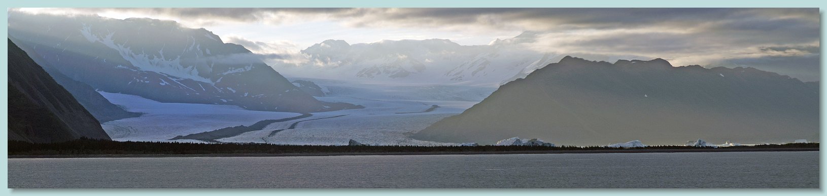
MS Zaandam Departure from Seward The day before our departure we had taken the Wildlife Tour of Resurrection Bay. By the time that our boat reached the western side of the bay the weather was overcast and showering. As a result the pictures that I took of Bear Glacier were very poor. Fortunately I had a second chance as the Zaandam cruised by it on the way out of Resurrection Bay. Bear Glacier is the largest glacier in the Kenai Fjords National Park. It originates in the Harding Icefield. It is a rapidly retreating and has a large freshwater lake between its terminus and the old moraine at the entrance to the bay. This panorama was made from four photographs I took from the balcony of our cabin about 9:45 pm. The white peaks seen at the front behind the land are not parts of the glacier, they are icebergs which have calved from the glacier and floated across the lake. You can get an idea of the size of these icebergs when you realize that the dark band across the front of the icebergs are full sized trees and just over 10 percent of the iceberg is even above water!. The dark stripes found down the center of a glacier are known as medial moraines formed when the lateral moraines of two large glaciers merge. Bear Glacier is so large that it has two distinct medial moraines. The distance between the two mountains on either side of the glacier is over two miles.  MS Zaandam Departure from Seward |
Alaska Trip - Glacier Bay Cruising - Tarr Inlet - Margerie and Grand Pacific Glaciers Panorama Monday, the first full day of the cruise, was spent at sea, traveling from Seward to Glacier Bay. There was nothing to see except water. We arrived at the mouth of Glacier Bay 8:30 am on Tuesday Morning. As late as 1794 the Grand Pacific Glacier extended to the mouth, presenting explorers with a wall of ice 2 miles wide and 4000 feet high. Shortly thereafter the glacier began to retreat up the bay with its current location being ~65 miles from the mouth of the bay. This is a panoramic picture made from five photographs taken at the head of Tarr Inlet at the end of the bay. On the right is the Grand Pacific Glacier. Since it is covered by rock debris from landslides and medial moraines it is almost unrecognizable as a glacier. According to one of the National Park Service Rangers on board the Zaandam for this portion of the cruise, the debris is up to 3 feet thick. She referred to it as a "black" glacier. It begins on the southern slopes of Mt Hay in the Saint Elias Mountains and flows for 35 miles first east through British Columbia, then south to Tarr Inlet. At its terminus it is almost 2 miles wide and is the widest glacier in the bay. The ice is about 150 ft thick, extending about 50 feet into the water. All the dirt on the glacier serves to insulate it so calving is relatively rare. On the left of the panorama is the more recognizable Margerie Glacier. Its source is on the southern slopes of Mount Root. It flows for 21 miles to the northeast also to Tarr Inlet. At its terminus the glacier is a little over 1 mile wide. The face is 250 feet high above the water, and it descends 100 feet into the water. It is this latter depth which allows large cruise ships such as the Zaandam to park close to its face. The ice flows at about 6 feet per day, so calving is common. There were three such events during our 2 hour stay at the inlet. I captured one of them in the photographs in the next picture collage. Due to the ship's location in the inlet, this panorama covers about 90 degrees. Margerie Glacier is closer and perpendicular to the Grand Pacific Glacier. Thus the distortion in their size and relative widths. One little personal note. The ship was serving hot chocolate while we were at Grand Pacific and Margerie glaciers. I purchased a large Holland America mug to have it in, and asked the waiter to "put a squirt of mint in it". Well, we had a failure to communicate. It came with a shot of Crème de Menthe. Well I wasn't about to let a large mug of hot chocolate go to waste, and after all, maybe the hot chocolate would evaporate the ethanol (in the closed container. Oh well, I guess I had more to drink on this cruise than I had in my previous 6+ decades :)  Alaska Trip - Glacier Bay Cruising - Tarr Inlet - Margerie and Grand Pacific Glaciers Panorama |
 Alaska Trip - Glacier Bay Cruising - Tarr Inlet - Margerie Glacier Calving Collage This collage show the latter half of a Margerie Glacier calving. I was very fortunate to get it. I was going down to the bow from the "Crow's Nest" where I had spent most of the day. As I walked through the door onto the Promenade Deck the calving started. I had my camera in my hand and started taking pictures. The pictures cover about 7 seconds of the ice fall, with the last picture being about 30 seconds later as the waves spread from the fall.  Alaska Trip - Glacier Bay Cruising - Tarr Inlet - Margerie Glacier Calving Collage |
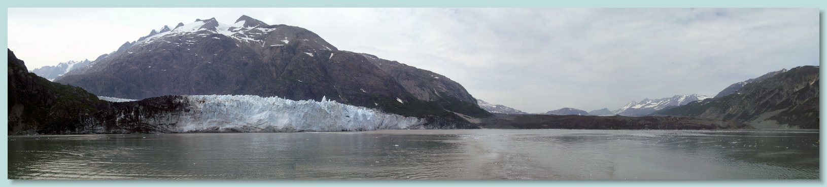
. Harbor Seal pupping activities occur from May through August and they like to use floating ice as \"haul outs\" for these activities. Since there is extensive floating ice at the terminus of the glacier, cruise boats may not get any closer to the glacier than Jaw Point, about 5 miles away. This picture was taken from that location. The air was quite hazy due to wild fires in western Canada. The resulting pictures were not as good as might be hoped. This is the best of the pictures and I had to Photoshop it extensively to eliminate the haze. The visible glacier terminus is over 5 miles away. At the left edge the terminus of Gilman Glacier can also be seen. The two glaciers regularly join and separate as they advance and retreat in their separate courses. Despite the haze, this view from Jaw Point was one of the most magnificent sights of the entire vacation.") Alaska Trip - Glacier Bay - Johns Hopkins Inlet - Johns Hopkins Glacier from Jaw Point After spending 2 hours in Tarr Inlet viewing those glaciers, we turned back and entered Johns Hopkins Inlet which has Johns Hopkins Glacier at its head. (Both were named after the university by an alumnus). Harbor Seal pupping activities occur from May through August and they like to use floating ice as "haul outs" for these activities. Since there is extensive floating ice at the terminus of the glacier, cruise boats may not get any closer to the glacier than Jaw Point, about 5 miles away. This picture was taken from that location. The air was quite hazy due to wild fires in western Canada. The resulting pictures were not as good as might be hoped. This is the best of the pictures and I had to Photoshop it extensively to eliminate the haze. The visible glacier terminus is over 5 miles away. At the left edge the terminus of Gilman Glacier can also be seen. The two glaciers regularly join and separate as they advance and retreat in their separate courses. Despite the haze, this view from Jaw Point was one of the most magnificent sights of the entire vacation.  Alaska Trip - Glacier Bay - Johns Hopkins Inlet - Johns Hopkins Glacier from Jaw Point |
Alaska Trip - Glacier Bay - Outbound Cruise - Humpback Whales Glacier Bay is a Humpback Whale sanctuary. According to the rangers on board, the number of whales spotted in Glacier Bay has been growing every year. We saw some on the inbound cruise, but they were too far away to get good pictures. .We were more fortunate on the outbound cruise. This whale was about a mile off the side of the boat. Since we only became aware of its presence when it blew and the speed of sound meant we didn't see it until 5 seconds afterwards, I don't have a picture of the actual blow, however in the first picture of the collage you can still see the blow hole above water and the cloud from its blow. The next 4 pictures cover the approximately one minute that the animal was at the surface up to its final goodbye wave of its fluke. Since it showed its 16 ft wide fluke, it is safe to assume that it was departing for a longer, deep dive. These pictures were shot at maximum zoom, so the distance orientation is a bit distorted. However you can see in the fluke picture the whale is swimming away from the ship. We also saw harbor seals hauled out on islets and rocks on the outbound cruise, and while I did get some decent pictures with my 400mm telephoto, none of them were as good as the photographs I took the previous Saturday during the Resurrection Bay Wildlife Cruise.  Alaska Trip - Glacier Bay - Outbound Cruise - Humpback Whales |
 For the record, in Juneau it was an eagle, and in Ketchikan it was a moose.") Alaska Trip - Haines - Disembarkation Overnight the Zaandam cruised from Glacier Bay to Haines with a scheduled arrival of 6am. disembarkation. I awoke at 4:30 to go out on the public balcony at the front of the ship to watch the arrival and docking. Although the sun was behind the mountains, it was already light. The fjord we were cruising up was gorgeous and the weather matched the scenery with clear blue skies. We were about 30 minutes behind another cruise ship which was continuing on to Skagway. The approach to the Haines dock was amazingly smooth. The ship came to a stop in position at dockside and the crew scrambled to throw lines to the shore crew for tie up. I then went back in for breakfast. Since the float trip down the Chillcat River was not scheduled until 10:30am, I decided to reconnoiter Haines. As I was to learn, the ship's photographer would be at the base of the gangplank with one of their number dressed up as an Alaskan animal, in this case a bear. As I came down the ramp I heard the mascot complaining about the heat, and I recognized her voice as one of the cute young assistants, thus the pose :) For the record, in Juneau it was an eagle, and in Ketchikan it was a moose.  Alaska Trip - Haines - Disembarkation |
. In addition to the raft trip, during my morning's reconnaissance I learned of a photographer's tour scheduled that afternoon for 4pm. I tried to make a reservation at the tour operator's office but was told that all reservations had to be made through the ship. However the ship's shore tour desk had told me that its only photographer's tours were at 8am and noon. After some running back and forth, the ship discovered that they did indeed have a 4pm tour and I went on it. I took some 200 photographs and received numerous hints on taking wildlife pictures. This is a collage of my best eagle pictures, from Haines, Ketchikan, and Juneau. The upper and center right pictures are from the float trip, with the center right bird being a juvenile. The lower right and center left pictures were taken on the photographer's tour. The upper and lower left are from a wildlife tour in Ketchikan. While I also took the central picture, it is a bit of a fudge - it is of a captive bird that was in the Juneau Raptor Center at the top of Mount Roberts. These pictures have lead me to two conclusions. I want to go back to Haines for their Alaska Bald Eagle Festival held every November, and I need a newer, full frame camera which would allow me to magnify my wildlife pictures. Now I only need to find the required $$$$$ :)") Alaska Trip - Eagle Collage One of the continuing highlights of the trip for me were all the bald eagles - starting in Anchorage and going all the way through Vancouver. Just outside Haines is the Chilkat Bald Eagle Preserve. It was established by Alaska in 1982. to "protect and perpetuate the world's largest concentration of Bald Eagles and their critical habitat". A natural phenomenon known as the "alluvial fan reservoir" creates. five miles of open water along the rivers during freezing months. A subterranean reservoir of coarse alluvial material through which the river water must percolate creates friction which results in a warmer water surface temperature and the ice free area. This phenomenon permits chum salmon to spawn late into the year, attracting the eagles. I had scheduled a mid day float trip through the preserve. On the trip we saw about 50 eagles, most of which were juveniles (which still have a dark head for their first 4 or so years). In addition to the raft trip, during my morning's reconnaissance I learned of a photographer's tour scheduled that afternoon for 4pm. I tried to make a reservation at the tour operator's office but was told that all reservations had to be made through the ship. However the ship's shore tour desk had told me that its only photographer's tours were at 8am and noon. After some running back and forth, the ship discovered that they did indeed have a 4pm tour and I went on it. I took some 200 photographs and received numerous hints on taking wildlife pictures. This is a collage of my best eagle pictures, from Haines, Ketchikan, and Juneau. The upper and center right pictures are from the float trip, with the center right bird being a juvenile. The lower right and center left pictures were taken on the photographer's tour. The upper and lower left are from a wildlife tour in Ketchikan. While I also took the central picture, it is a bit of a fudge - it is of a captive bird that was in the Juneau Raptor Center at the top of Mount Roberts. These pictures have lead me to two conclusions. I want to go back to Haines for their Alaska Bald Eagle Festival held every November, and I need a newer, full frame camera which would allow me to magnify my wildlife pictures. Now I only need to find the required $$$$$ :)  Alaska Trip - Eagle Collage |
 We proceeded to the Mount Roberts Tram. We actually made two trips up Mount Roberts, it our first activity in the morning and our last activity in the afternoon. In addition to the beautiful view of Juneau, our second trip up featured a young man dropping to his knee, producing a ring and proposing to his girlfriend. Despite turning all kinds of red, she accepted and the rest of the riders applauded. At the top we found the expected collection of gift shops and restaurants. It is also the home of the Juneau Raptor Center, which despite its name will help any injured bird, regardless of species. One of the Center's exhibits included this 7 ft eagle wing span for comparison They had an injured eagle on display and this is where I took the central photograph in my eagle collage. Another attraction at the top is the Chilkat Theater. Normally it shows a free short film, but while we were up there a local acoustic music group, the Alaska String Band, was performing. They had an interesting range of music. I ended up buying one of their CDs.") Alaska Trip - Juneau - Mount Robinson Tram The Zaandam left Haines at 9pm and arrived in Juneau at 8am. During breakfast I had my most memorable view of an eagle the entire trip - one flew by the window of the dining area probably about 10 feet away from the ship. It was magnificent. After breakfast we ducked around the crowd of passengers being photographed disembarking (with the eagle mascot) We proceeded to the Mount Roberts Tram. We actually made two trips up Mount Roberts, it our first activity in the morning and our last activity in the afternoon. In addition to the beautiful view of Juneau, our second trip up featured a young man dropping to his knee, producing a ring and proposing to his girlfriend. Despite turning all kinds of red, she accepted and the rest of the riders applauded. At the top we found the expected collection of gift shops and restaurants. It is also the home of the Juneau Raptor Center, which despite its name will help any injured bird, regardless of species. One of the Center's exhibits included this 7 ft eagle wing span for comparison They had an injured eagle on display and this is where I took the central photograph in my eagle collage. Another attraction at the top is the Chilkat Theater. Normally it shows a free short film, but while we were up there a local acoustic music group, the Alaska String Band, was performing. They had an interesting range of music. I ended up buying one of their CDs.  Alaska Trip - Juneau - Mount Robinson Tram |
 the thumb is for chum (salmon), 2) the pointer finger can be used to sock someone in the eye (sockeye salmon) 3) the middle (longest) finger is the king (king or chinook salmon), 4) the ring finger is the one you would wear a sliver ring on (silver or coho salmon), and 5) the pinky finger is pink salmon (the most common salmon). We went into the visitors center where we could watch through a window the harvesting of eggs from the female salmon and placing them into 5 gallon buckets. Then we could see other staff members squeezing the milt (sperm) from about 10 male salmon into these same buckets and stirring everything to promote fertilization. As is the case with wild spawned salmon, the hatchery fish die either as a result of the harvesting, or shortly thereafter. The fresh water used to raise the juvenile salmon and attract the returning salmon to the hatchery comes from the Salmon Creek Dam located on the mountainside behind the hatchery. At the peak they use 10,000 gallons of fresh water per minute. Since we were not on a time limited organized tour, we wandered into the area containing the juveniles. There a young staff member spent quite some time answering our questions. In addition to the salmon work, the hatchery contained several salt water aquariums including one that was floor to ceiling large cylinder with gorgeous fish and other marine life.") Alaska Trip - Juneau - Macaulay Salmon Hatchery Composite After our morning trip up Mount Roberts we caught a cab and went to the Macaulay Salmon Hatchery. The salmon were running and the number of chum salmon in the water below, going up the 450-foot long fish ladder, and trying to get into the hatchery was unbelievable. While we were outside the hatchery we listened to a tour guide explain the processing in the hatchery. In that explanation she described the five finger method for remembering the five varieties of Salmon: 1) the thumb is for chum (salmon), 2) the pointer finger can be used to sock someone in the eye (sockeye salmon) 3) the middle (longest) finger is the king (king or chinook salmon), 4) the ring finger is the one you would wear a sliver ring on (silver or coho salmon), and 5) the pinky finger is pink salmon (the most common salmon). We went into the visitors center where we could watch through a window the harvesting of eggs from the female salmon and placing them into 5 gallon buckets. Then we could see other staff members squeezing the milt (sperm) from about 10 male salmon into these same buckets and stirring everything to promote fertilization. As is the case with wild spawned salmon, the hatchery fish die either as a result of the harvesting, or shortly thereafter. The fresh water used to raise the juvenile salmon and attract the returning salmon to the hatchery comes from the Salmon Creek Dam located on the mountainside behind the hatchery. At the peak they use 10,000 gallons of fresh water per minute. Since we were not on a time limited organized tour, we wandered into the area containing the juveniles. There a young staff member spent quite some time answering our questions. In addition to the salmon work, the hatchery contained several salt water aquariums including one that was floor to ceiling large cylinder with gorgeous fish and other marine life.  Alaska Trip - Juneau - Macaulay Salmon Hatchery Composite |
  Static pictures do not do the scene at the Macaulay Salmon Hatchery justice. This is a 30 second video I took first of the fish outside, then of the fish inside the hatchery trying to get into the processing area. At the start, in the background you can hear the tour guide talking about the difference between "fish farming" which is illegal in Alaska and the hachery, which she refered to as "fish ranching"  |
 Alaska Trip - Juneau - Glacier Gardens Rainforest Adventure Our last stop in Juneau was Glacier Gardens Rainforest Adventure. It is a combination of interestingly designed botanical garden and a golf cart tour up the mountain side through the Tsongas Rainforest. This picture shows the garden's trademark upside down tree "Flower Towers". They are local Sitka Spruce and Western Hemlock which have fallen naturally that have been turned upside down, driven several feet into the ground. Their root balls, having been previously trimmed and cleaned, are covered with a mesh netting covering layer a of moss to hold soil and plants as well as capture rain water and distribute nutrients. The tops are planted with up to 100 individual plants including petunias, daisies, Creeping Charlie, dahlia, fuchsia, verbena, bacopas, begonias, Persian carpet lamium, and or bidens. Spikes or dracaena form the large 'palm tree' like plant on the tops.  Alaska Trip - Juneau - Glacier Gardens Rainforest Adventure |
 and you got a perfect view of the parallel land and water runways. There was also an eagle soaring overhead against the Douglas Island mountains and above the approach of the landing aircraft. This picture of Ed and Lucinda was taken by a fellow tourist on the boardwalk. That \"road\" in the background is the approach end of JNU Runway 8 which is 150 feet wide.") Alaska Trip - Juneau - Glacier Gardens Rainforest Adventure At the top the Tsongas Rainforest tour, some 580 feet up, the guide parked the golf cart and directed us to a boardwalk deck providing a panoramic view of the Juneau area. The viewpoint was directly over the Juneau International Airport (JNU) and you got a perfect view of the parallel land and water runways. There was also an eagle soaring overhead against the Douglas Island mountains and above the approach of the landing aircraft. This picture of Ed and Lucinda was taken by a fellow tourist on the boardwalk. That "road" in the background is the approach end of JNU Runway 8 which is 150 feet wide.  Alaska Trip - Juneau - Glacier Gardens Rainforest Adventure |
 Alaska Trip - Juneau to Ketchikan Formal Dinner Two of the nights that we were on the Zaandam were designated as "Formal Evenings". The first formal night was the Monday we were at sea, the second was the evening after the Juneau port call. The restaurant did provide coats and ties at the check-in. They also turned away men in shorts. Lucinda and came prepared - I have not had much opportunity to wear my tuxedo since Steven graduated. During the dinner both nights the onboard photographer came around and took pictures of everybody in the main dining room. We thought that the second set of pictures were better than the first set. This is the one of the two of us together fancied up.  Alaska Trip - Juneau to Ketchikan Formal Dinner |
 Alaska Tour - Ketchikan - Arrival Our arrival in Ketchikan was notably different from our arrival in any other ports - we had an armed escort. Two coastguard response boats complete with machine guns. I did not notice when the boats took up station, but it must have been several miles outside of the harbor. They took station on either side of the Zaandam and intercepted any craft - either water or air - which came towards her. They left us when the ship started maneuvering for docking.  Alaska Tour - Ketchikan - Arrival |
 Alaska Trip - Ketchikan - Wildlife Tour - When Eagles Clash #1 In Ketchikan we waited until after we got off the ship and saw what the local tour operators had to offer before we went anywhere. We decided on a wildlife and Saxman Native Village tour. Our guide was a Native American and in addition to the commentary on the sights we were to see, he had some rather caustic comments about the cruise lines and their wholly owned "local sights" and gift shops which did not employ any of the locals. Instead the cruise lines brought in employees at the start of the season, then moved to the Caribbean for the winter season. He took us on the island's "highway" around to several viewpoints. The most interesting one was a place called Bear Creek which lead up to a salmon hatchery. With the salmon around, there were about 10 eagles in the area. Surprisingly there were no bears. Our guide commented that typically there were only eagles or bears there, and he never knew which. While there I photographed this composite entitled "When Eagles Clash - 1" While we were watching two eagles came out of the forest about 1500 feet away. Eagle #2 obviously upset eagle #1 Their screeching drew my attention and I started taking pictures. The first picture in this composite shows them just after they came out of the forest. In the second eagle #1 has turned around mid air to confront his pursuer. By the third eagle #1 is upside down baring his talons at eagle #2. In the final picture the eagles are departing the area of the first conflict with #2 taking the high road, #1 the low. The confrontation only lasted 3 seconds. More to follow in the next composite - "When Eagles Clash - 2".  Alaska Trip - Ketchikan - Wildlife Tour - When Eagles Clash #1 |
Alaska Trip - Ketchikan - Wildlife Tour - When Eagles Clash #2 These pictures, taken about 10 seconds later show round 2 of the dispute and the birds have flown to within 500 feet of me. In the first picture eagle #1 has taken the low road and is trying to leave the area. Eagle #2 has other ideas however and it has begun a dive down. In the second picture it has further closed the distance between them as they approach a boardwalk belonging to Alaska Canopy Adventures, a cruise ship zip line attraction. By the third picture eagle #1 is aware of eagle #2's approach and is turning over to repel it. By the next picture eagle #2 appears to be having second thoughts about continuing the altercation, and in the final picture it is heading up and eventually away to the right while eagle #1 followed and turned left. Both flew out of sight. The whole event lasted less than 15 seconds. I was fortunate to have had my camera set for rapid fire exposures and at the ready.  Alaska Trip - Ketchikan - Wildlife Tour - When Eagles Clash #2 |
. This pole would have been set into the front of a Tribal House and on special occasions, people would enter the Tribal House through this opening. The opening also represents the bear den. The figure at the top is one of the Kats Bear children. The man figure is Kats being held by his bear wife. The face at the bottom is the human wife. Notice the Labret through her lip. Kats is a mythical figure similar to Hercules. According to legend, Kats left his human village and married a spirit bear. Later, he went back to the village to help his family hunt and while there accidentally looked upon his human wife, breaking a promise to his bear wife. Upon returning to this bear family, his bear wife was angry with him and in loyalty to their mother, his sons devoured him.") Alaska Trip - Ketchikan - Wildlife Tour - Saxman Native Village According to a sign posted in the village, "Saxman - Legend: = Tlingit Indian Village, Established in 1894, is named for School Teacher Samuel Saxman, one of three men lost December of 1886 while scouting for a new location for people of Tongass and Cape Fox villages. Totems here comprising world's largest collection including poles moved from Pennock, Tongass, and village islands and from old Cape Fox village at Kirk Point. Many are Poles restored under federal works project directed by the US Forest Service beginning in 1939. The picture on the left shows the Clan House area with seven totem poles. On the far right is a plain pole with a figure of Abraham Lincoln extending above the hill in the background. This is an example of a commemorative pole, marking the signing of a peace pact between two rival Tlingit Tribes. The figure of Lincoln at the top of the pole represents the U.S. Revenue Cutter “Lincoln” which was instrumental in finalizing the peace by its presence. The figure of Lincoln is used rather than the ship because the figure on the top of the pose must be an animate object. However the only picture that the cutter had of its namesake was a 3/4 view from the knees up. The carvers thought that was his full picture and thus made his legs very short. Towards the center just to the right of the clan house in the background is another plain pole topped with a black figure with a white face. This is an example of a Ridicule Pole, raised to make fun of a person or clan. Here the person being made fun of is William H. Seward, Secretary of State under Abraham Lincoln. In the summer of 1869, Seward stopped at Ft. Tongass where he was entertained by Chief Ebbits of the Tlingit Nation. Seward was treated like royalty and given many gifts. In Tlingit Culture, he was expected to return the honor by giving gifts to the Tlingit people. He did not do so, so the Tlingit people painted nostrils and ears red, signifying stinginess. The picture on the right is Ed standing in front of the Kats & Bear Wife Pole, one of eleven poles on Totem Row (leading to the Clan House area). This pole would have been set into the front of a Tribal House and on special occasions, people would enter the Tribal House through this opening. The opening also represents the bear den. The figure at the top is one of the Kats Bear children. The man figure is Kats being held by his bear wife. The face at the bottom is the human wife. Notice the Labret through her lip. Kats is a mythical figure similar to Hercules. According to legend, Kats left his human village and married a spirit bear. Later, he went back to the village to help his family hunt and while there accidentally looked upon his human wife, breaking a promise to his bear wife. Upon returning to this bear family, his bear wife was angry with him and in loyalty to their mother, his sons devoured him.  Alaska Trip - Ketchikan - Wildlife Tour - Saxman Native Village |
 Alaska Trip; - Ketchikan - Wildlife Tour - Creek Street The tour ended at Creek Street. Physically it is a boardwalk perched on pilings along the banks of Ketchikan Creek. Historically it is a former Red Light District where "both men and salmon swam upstream to spawn". Now it consists of a locally owned tourist shops, museums and galleries. The best known of the buildings is Dolly's House, paying tribute to the city's most celebrated hooker, Dolly Arthur. It is the pastel green house across the creek at the far end. At the end of the boardwalk is "The Married Man’s Trail" which provided patrons a quick exit to avoid hefty fines for being caught at one of the brothels during one of the frequent police raids on the brothels.  Alaska Trip; - Ketchikan - Wildlife Tour - Creek Street |
 Events included an ax throw, chopping and cutting 12\" diameter logs in various positions, pole climb, log rolling, and cutting a little chair out of a log. The winner of the ax throw was particularly amazing with bulls eye after bulls eye. However the looser was so far off of the mark that I suspect he lost intentionally. All in all, their skills surprised me.") Alaska Trip; - Ketchikan - Great Alaskan Lumber Jack Shore The last activity in Ketchikan was the Great Alaskan Lumber Jack Show. It was a very corny and cheesy tourist trap, but it was fun. The show was a "competition" between two 2-man teams, one nominally the US, the other Canadian. The US team was behind until the very end when they "pulled out a win" :-) Events included an ax throw, chopping and cutting 12" diameter logs in various positions, pole climb, log rolling, and cutting a little chair out of a log. The winner of the ax throw was particularly amazing with bulls eye after bulls eye. However the looser was so far off of the mark that I suspect he lost intentionally. All in all, their skills surprised me.  Alaska Trip; - Ketchikan - Great Alaskan Lumber Jack Shore |
 was spent at sea. Throughout the cruise I spent a lot of time on deck looking for interesting pictures. The scenery was gorgeous, but I forgot to adjust the white balance of my camera so none of the pictures turned out. However we did have one sighting of Orcas. They were several miles off the side of the ship. I took the pictures at the maximum 200 mm zoom, and even with that they were just small images in the center of a pictures of open water. The orca on the left is most definitely a male. The one on the right is probably a female.") Alasaka Trip - Inside Passage - Orcas We departed Ketchikan at 7 pm, cruising south towards Vancouver. All of the next day (Saturday) was spent at sea. Throughout the cruise I spent a lot of time on deck looking for interesting pictures. The scenery was gorgeous, but I forgot to adjust the white balance of my camera so none of the pictures turned out. However we did have one sighting of Orcas. They were several miles off the side of the ship. I took the pictures at the maximum 200 mm zoom, and even with that they were just small images in the center of a pictures of open water. The orca on the left is most definitely a male. The one on the right is probably a female.  Alasaka Trip - Inside Passage - Orcas |
 Alaska Trip - Inside Passage - Towel Animals One of the unexpected features of our cruise were the towel animals that the steward placed on our bed each evening. This orangutan was the most complicated and last animal to appear. The eyes are a simple paper cutout stuck to the towel.  Alaska Trip - Inside Passage - Towel Animals |
 a picture of a decorated fiberglass orca in the upper center. There were a number of these throughout the city. I assume it was an art project similar to either the pandas or party animals in DC. And 2) the left center image of trumpet player below an orca topiary.") Alasaka Trip -Victoria - Inner Harbor and Buskers Festival Collage We arrived in Vancouver at 7am. After disembarking and clearing customs we caught a Pacific Coach Lines Cross Water trip at the cruise terminal. The trip departed at 11am, with a scheduled arrival in Victoria at 3:20 pm. The trip included a 90 minute ferry trip. The bus was the first on and therefore the first off of the ferry. When we arrived at the terminal the ferry backed into the birth. When the car doors opened there was an impressive view of turbulent water kicked up by the engines. Surprisingly to me, once we landed there was still another 30 minutes of driving to get to Victoria. To complicate the situation, downtown Victoria was holding both an International Busker's Festival and an antique car parade. As a result it took the bus an additional half hour to go the last five blocks to the bus terminal. After we got off the bus we walked the two blocks to our hotel, checked in, and then walked down to the inner harbor where the festival was going on. This is a collage of pictures I took both then, and the next afternoon awaiting the bus back to Vancouver. Two interesting images in the collage are 1) a picture of a decorated fiberglass orca in the upper center. There were a number of these throughout the city. I assume it was an art project similar to either the pandas or party animals in DC. And 2) the left center image of trumpet player below an orca topiary.  Alasaka Trip -Victoria - Inner Harbor and Buskers Festival Collage |
 Alaska Trip - Victoria - Buchart Gardens Collage The next day we rented a car and drove north from Victoria to visit Buchart Gardens. The gardens were originally a limestone quarry used to produce portland cement for customers from San Francisco to Vancouver. Then owners, Robert and Jennie Buchart built their home near the quarry, After the limestone deposits were exhausted, Jennie, brought in topsoil and converted the quarry into a sunken garden. As the years went on, they created additional specialty gardens in the vicinity of their home. The gardens were taken over by their grandson Ian Ross. They are magnificent. I took some 100 pictures during our visit. This is a collage of individual blossom images.  Alaska Trip - Victoria - Buchart Gardens Collage |
 Alaska Trip - Victoria - Buchart Gardens Collage This is another collage of Buchart Gardens. While the previous one concentrated on individual blossoms, this one tries to capture the overall architecture and organization of the gardens. Not shown in either collage are the many kinetic wind and water driven sculptures and fountains.  Alaska Trip - Victoria - Buchart Gardens Collage |
 Alaska Trip - Victoria - Victoria Butterfly Gardens Collage Our next stop were the Victoria Butterfly Gardens which are located on the road to/from Buchard Gardens. In addition to butterflies they also had tropical birds, lizards and a fish pond which included koi, turtles, and frogs. The most spectacular butterfly was the Blue Morpho. They have a metallic-blue on the top of their wings but the underside has a much duller pattern of black and yellow ringed eyespots. Needless to say they seemed to be the most popular attraction, but the most difficult to photograph - when alighted they would bring their wings together above their backs showing only the duller side. Fortunately persistence paid off and I did get several pictures. In the collage you can see them and the center right side image shows one alighted with its wings together. The greenish yellow butterfly in the upper right is another spectacular species: the Tailed Jay, aka the Green Spotted Triangle.  Alaska Trip - Victoria - Victoria Butterfly Gardens Collage |
 Alasaka Trip -Victoria - Inner Harbor - An Empress Hotel Garden We left the Victoria Butterfly Gardens and drove back to Victoria. Since we still had a couple of hours before the bus back to Victoria left. We decided to drive west and north from Victoria on the Trans Canada Highway. We drove about 45 minutes north through more magnificent scenery. We then returned to Victoria, turned in the rental car and walked to the bus depot. There was still some time until the bus left so we walked across the street to a garden by the Empress Hotel. Lucinda was tired so she decided to sit in the garden and read while I continued down to the inner harbor and took more pictures, some of which are on the Victoria Collage. The bus back to Vancouver departed at 5:45 pm and dropped us off at our Vancouver hotel around 10 pm. While we were driving back on the mainland there was a spectacular view of a full moon rising beside Mount Baker. Unfortunately the bus was not a good place to take pictures from :(.  Alasaka Trip -Victoria - Inner Harbor - An Empress Hotel Garden |
 and caught a free shuttle to Capilano Suspension Bridge Park, a private park built around a hemp rope and cedar plank foot suspension bridge over the Capilano River Canyon. The original bridge was built in 1889 to provide access to the rain forested land on the western side of the canyon. Rebuilt using wire cable in 1904. It has been modernized and completely rebuilt since then. The bridge stretches 450 feet across and 230 feet above the River. Two additional attractions have been added to the park since the bridge was first built. Treetops Adventure consists of several suspension bridges between massive Douglas Firs. Cliff Walk is a series of cantilevered and suspended walkways along the granite cliff face on the east side of the canyon. In several places the walkway is transparent. We spent the morning at the park. First going over the bridge to the west side. and exploring the nature trails. While Lucinda continued exploring the ground trails, I took to the trees. Considering that it was a Tuesday morning, the park had a surprising number of visitors as you can see from my picture of the Treetops (more like mid trees) Adventure. When we were finished on the west side we walked back across the bridge had lunch and walked along the Cliff Walk. We ended our stay with an Ice cream cone and then took the shuttle back to down town Vancouver.") Alasaka Trip - North Vancouver - Capilano Suspension Bridge Park Tuesday Morning after breakfast at our Vancouver hotel we walked up to Canada Place (the cruise ship dock) and caught a free shuttle to Capilano Suspension Bridge Park, a private park built around a hemp rope and cedar plank foot suspension bridge over the Capilano River Canyon. The original bridge was built in 1889 to provide access to the rain forested land on the western side of the canyon. Rebuilt using wire cable in 1904. It has been modernized and completely rebuilt since then. The bridge stretches 450 feet across and 230 feet above the River. Two additional attractions have been added to the park since the bridge was first built. Treetops Adventure consists of several suspension bridges between massive Douglas Firs. Cliff Walk is a series of cantilevered and suspended walkways along the granite cliff face on the east side of the canyon. In several places the walkway is transparent. We spent the morning at the park. First going over the bridge to the west side. and exploring the nature trails. While Lucinda continued exploring the ground trails, I took to the trees. Considering that it was a Tuesday morning, the park had a surprising number of visitors as you can see from my picture of the Treetops (more like mid trees) Adventure. When we were finished on the west side we walked back across the bridge had lunch and walked along the Cliff Walk. We ended our stay with an Ice cream cone and then took the shuttle back to down town Vancouver.  Alasaka Trip - North Vancouver - Capilano Suspension Bridge Park |
 Alasaka Trip - North Vancouver - Capilano Suspension Bridge Park While I was up walking in the trees, Lucinda preferred to keep her feet on terra firma. After wandering around she stopped to rest for a while. This is the bench I found her on after I came down.  Alasaka Trip - North Vancouver - Capilano Suspension Bridge Park |
 attempt at developing my own black and white pictures. This is the closest I have been to a kestrel since then.") Alasaka Trip - North Vancouver - Capilano Suspension Bridge Park One of the ancillary attractions in the park is "Raptors Ridge Birds of Prey" an area where handlers bring captive birds. This is a female kestrel. I was attracted to it because in the late 60s my brother Peter caught and trained one back in high school at Randolph AFB in San Antonio Texas. We had it for about a year before he released it, and for the rest of the time we were stationed there it would occasionally come by looking for a handout. It provided the model for my first (and only) attempt at developing my own black and white pictures. This is the closest I have been to a kestrel since then.  Alasaka Trip - North Vancouver - Capilano Suspension Bridge Park |
") Alasaka Trip - North Vancouver - Capilano Suspension Bridge Park When we were finished on the west side we walked back across the suspension bridge, had lunch and Lucinda hit the gift shop. Next we took the Cliff Walk. Unlike the suspension bridges of the main bridge and of Treetops adventure, the walkway of Cliff Walk was securely fastened to the side of the cliff and did not move around as we walked. As a result Lucinda was comfortable on it, although she passed on going out on the cantilevered overlooks which had a transparent floor. Here she is waiving back at me, probably wondering what is taking me so long :)  Alasaka Trip - North Vancouver - Capilano Suspension Bridge Park |
 Alasaka Trip - North Vancouver - Capilano Suspension Bridge Park After I caught up to her, I went out on one of the transparent floor cantilevered overlooks and she took this picture of me. We completed the Cliff Walk and ended our stay with an ice cream cone. We took the shuttle back to down town Vancouver.  Alasaka Trip - North Vancouver - Capilano Suspension Bridge Park |
 a featured attraction of Gastown is the Steam Clock. It was built to camouflage a steam vent in the middle of the sidewalk. I was tired of carrying my big camera and I had left it in the hotel. As a result I only had my small water/shock proof pocket camera, and I had not noticed that it was set to video mode. This picture is a snapshot from the short video a fellow tourist took of us in front of the steam clock.") Alasaka Trip - Vancouver - Gastown Steam Clock We returned to our hotel, rested a little, then went to the Vancouver Art Gallery. We went through two of the exhibits. "Grand Hotel: Redesigning Modern Life" which chronicled the growth of both large hotels and smaller motels. It included scale models of several of the hotels. " Persuasive Visions: 17th Century Dutch and Flemish Masterworks and Contemporary Reflections" was a collection of works on loan from the Rijksmuseum, Amsterdam contrasted with works in similar genres by contemporary artists. Dinner was at a little crepes restaurant which apparently had never heard of a "martini with a lemon twist". After several attempts Lucinda settled for one with a lemon wedge. After dinner we walked to Gastown - Vancouver's historic first down town. While not historic (having been built in 1977) a featured attraction of Gastown is the Steam Clock. It was built to camouflage a steam vent in the middle of the sidewalk. I was tired of carrying my big camera and I had left it in the hotel. As a result I only had my small water/shock proof pocket camera, and I had not noticed that it was set to video mode. This picture is a snapshot from the short video a fellow tourist took of us in front of the steam clock.  Alasaka Trip - Vancouver - Gastown Steam Clock |
 Outside they had dolphins (see the next video of them), beluga whales, African penguins and a tropical rain forest. Having photographed white ibises at Pinckney Island National Wildlife Refuge, discovering the scarlet ibis here was a pleasant surprise.") Alasaka Trip - Vancouver - Stanley Park Aquarium Collage Wednesday was the last day of our trip. We checked out of our hotel and left our luggage there until the evening. We caught a city bus to Stanley Park where our first stop was the aquarium. This collage is the product of the pictures I took in the aquarium. The feature exhibit was " Jelly Invasion" on jelly fish (see the two images on the right ) Outside they had dolphins (see the next video of them), beluga whales, African penguins and a tropical rain forest. Having photographed white ibises at Pinckney Island National Wildlife Refuge, discovering the scarlet ibis here was a pleasant surprise.  Alasaka Trip - Vancouver - Stanley Park Aquarium Collage |
 The Dolphins at the Stanley Park Aquarium were an unexpected delight. In addition to the above water viewing, there was a large transparent wall in the basement of the aquarium where you could watch them underwater. We did not have enough time to stay for a show, but we did get to watch a training period. This 30 second video shows one of them jumping.  |
 and went past both the Brockton Point Lighthouse (upper left) and \"Girl in a Wetsuit\" (lower left). This latter statue was created and placed after an attempt to get permission to copy Copenhagen's \"Little Mermaid\" failed. Instead a modern diver statue reminiscent of the Little Mermaid was created. The last image (center left) in the collage is from the Shakespeare Garden. It is an arboretum featuring trees mentioned in his plays and poems. The trees have plaques that display the species of tree and the associated quote from Shakespeare. On our way back from Stanley Park we stopped and toured Christ Church Cathedral in downtown Vancouver, then proceeded to Chinatown where we visited the Dr. Sun Yat-Sen Classical Chinese Garden. After a very informative tour of the garden, we got a Chinese dinner, returned to the hotel to retrieve our luggage, took a taxi to Vancouver International Airport and caught our flight home. End of Trip :(") Alasaka Trip - Vancouver - Stanley Park Collage After the aquarium we went for a horse drawn wagon tour of the eastern side of the park. This is a collage of photographs I took both on that picture and afterwards. We stoped at the Brockton Point Totem-Pole Display (upper center and right side of the collage) and went past both the Brockton Point Lighthouse (upper left) and "Girl in a Wetsuit" (lower left). This latter statue was created and placed after an attempt to get permission to copy Copenhagen's "Little Mermaid" failed. Instead a modern diver statue reminiscent of the Little Mermaid was created. The last image (center left) in the collage is from the Shakespeare Garden. It is an arboretum featuring trees mentioned in his plays and poems. The trees have plaques that display the species of tree and the associated quote from Shakespeare. On our way back from Stanley Park we stopped and toured Christ Church Cathedral in downtown Vancouver, then proceeded to Chinatown where we visited the Dr. Sun Yat-Sen Classical Chinese Garden. After a very informative tour of the garden, we got a Chinese dinner, returned to the hotel to retrieve our luggage, took a taxi to Vancouver International Airport and caught our flight home. End of Trip :(  Alasaka Trip - Vancouver - Stanley Park Collage |
Generated by jAlbum 11.5, Matrix 10.5